
The ancient Indian civilization, popularly known as the Indus Valley Civilization, was not necessarily limited to the Indus Valley, but was spread all over from Kashmir in the north to the Narmada Valley in central Gujarat. There have been many sites excavated in central and northern Gujarat and the Saurashtra peninsula. The most famous site is Lothal, which is about 40 miles south of Ahmedabad and about 30 miles northwest of Khambat. Many of these sites are located in present day Pakistan, the most famous being Harappa in Punjab and Mohanjo-dero in Sindh on the Indus River. There is evidence that trade relations with Mesopotamia and Egypt existed via ports along the gulf of Khambat.
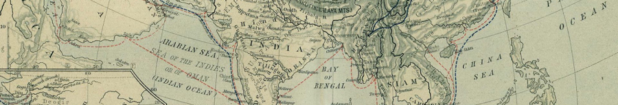
India had trade relations with the west via the Arabian Sea and with the east via the Bay of Bengal. There were three different groups:
-
✴In the South the trade was essentially the transfer of goods from the West to East and vice-versa.
-
✴In the East ports near present day Calcutta traded goods made in India with the East (Indonesia, Southeast Asia and China).
-
✴In the West ports traded gods made in India with Mesopotamia and Egypt and later on with Greece and Rome.
-
A small part of the trade went through a land route via the Khyber Pass. Since the West had a more advanced civilization, the biggest share of India’s international trade went via the west coast ports. Saurashtra and Kutch always had small ports in operation and even today have a number of ports, the biggest being Kandla and Bhavanagar.
Along the western sea board from Khambat in the north to Kalyan in the south there were a number of ports. Bharuch (Bhrugukruch) at the mouth of the Narmada River was the most well known for almost 2000 years. It closed when silt from the river made the waters too shallow. Later on Khambat and Surat developed and were the most important ports of India. Until the 16th century, there were also the smaller ports of Kavi, Dahej, Sanjan, Vasai, Soppra and Kalyan. The first two are still in operation today on a small scale. Sanjan is where the Parsis (Zoroastrians) who came from Iran settled in Gujarat. Vasai, Soppra and Kalyan are all now part of greater Mumbai. All of these ports and the trade of India had a big impact on western India and particularly what we now call Gujarat. Many varieties of ships carried the goods across the ocean. On land, there was a different problem.
Railways were invented in 1800 and were built in India beginning in 1850. By 1900 or 1910 most major cities were connected via the rails. Autos and roads came in the 20th century. Until that time, animal drawn vehicles were the norm. Camels, horses and bullocks were employed to pull carts and wagons. It is remarkable that for more than 3000 years that was how goods were transported.
Trading routes were developed from the ports to the interior of India. The bullock carts or camel vans could travel only 30 to 40 miles per day and then had to rest for the night. Resting places were established along the routes and small towns grew at such places. These towns soon became market places for the surrounding villages. Hundreds of such towns came into existence. Kapadvanj was one of such towns. The big impact on the area (Gujarat and its neighboring places) were three fold:
-
✴A large number of people naturally became traders, businessmen and bankers (money lenders). Many travel as part of caravans to different parts of India and then settle there.
-
✴Conversely, merchants from different parts of India came to Gujarat and then settled there adopting Gujarat as their permanent residence.
-
✴Gujarat thus became more cosmopolitan than the other provinces and states of India. Its people became merchants and this tradition has continued to this day.
-
Trade brought money and soon these towns became prosperous and for safety they built forts
around them. Most of the towns were near rivers or they built stepwells for water supply. Kapadvanj
also had a fort with 5 gates. One was demolished when I was in the 5th or 6th grade. Another was
demolished when I was in the 10th grade. The other three were in existence at least until 1967. I do not
know the situation at present. The fort wall was in very bad shape [when I left], though it still exists
in some places. Kapadvanj is also situated on the bank of the Mohar River and another river called
the Varansi, which joins the Mohar about two miles south of the town. The water of the town is drawn
from the Varansi and a water purification plant was built in 1922/25. A number of wells and stepwells
were also built in the past. Some of those stepwells are still in use today. The original town was built
on the right bank of the river more than 1000 years ago. The present town is on the left bank of the
river and the fort was built about 800 years ago. Meanwhile the big stepwell (known as Kundavav) in
the middle of the town was built in the 10th century. (see photo on right.)
Sir Thomas Monroe (Ambassador of Britain) landed at Khambat and presented his papers to the Mogul Emperor at Ahmedabad. It was there the British were given a permit to trade with India and they decided to open their first trading post at Surat.
By the end of the 17th and the beginning of the 18th century ships were getting bigger and then came the steamship. England was at the head of the industrial revolution and soon found that the bigger ships could not enter the port of Surat except at high tide. (Surat is on the bank of the River Tapti, about twenty miles inland from the ocean.) They began to look for another port with deeper waters and soon found that the bay on which the old Kalyan port was located was deep enough between the islands of Elephanta and Colaba. Soon the Port of Mumbai (Bombay) was established. Slowly the port of Surat went down and Khambat was completely closed. Mumbai grew and all the ports between Khambat and Mumbai lost their importance.
When the railways came to India (around 1850) the first was built between the new Port of Mumbai and Kalyan (via Thanne, now a suburb of Mumbai). The rails were built by private companies. One called the GIP (Great Indian Peninsular) Railway built the train to Kalyan and then further east across the Shayadri Mountain to Pune (Poona) and south to Madras, and then another one from Kalyan to Calcutta. Another company called BB&CI (Bombay, Baroda and Central India) Railway was built from Mumbai to Surat and Bharuch, then along the old trade route to Baroda and in wards to central India. From Baroda the other line went to Ahmedabad and onwards towards Rajasthan and Delhi. Similarly, other rail companies will build out of the port cities of Madras and Calcutta. Soon the old trade routes would die and only the towns that were lucky to be part of the railways would survive, some would even grow. The rest of the towns on the old trade routes would loose business and went down. Kapadvanj was one of the unlucky ones. Slowly people from those towns moved to where the business had moved, to Mumbai.
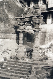
Kapadvanj Stepwell